 |
|||||||||||||||
|
Another essential problem had to be solved before MEB could be started: the map grid. Since the first computer-aided distribution atlas (HEATH 1970) the UTM grid has been utilised in all British atlas projects and recommended by the European Invertebrate Survey for European distribution maps. The UTM grid consists of squares of scaleable side size, e.g. 1 km, 10 km, 50 km or 100 km. It would be a wonderful universal system if the Earth were flat, which it is not. Because the Earth is round compensating triangles are necessary to counterbalance the squares. This means that the ideally shaped square, the only true reason for using this system, is not generally available on the map.
In Great Britain almost every good map sports the UTM grid and this makes its use convenient; furthermore problems with interposed compensation triangles are in the UK negligible. In Europe the UTM grid is only exceptionally found on maps; the last map of Europe containing the UTM grid - the Series 1404 Military Map of the World - has been completely out of print since about 1975, but already, some 5-10 years prior to 1975, maps were no longer available for many European countries. Should a standard map be used, it must be made available to all recorders, which would be both a difficult and a very costly undertaking. Apart from this, the UTM grid is not a standard European system. In many European countries distribution maps of both plant and animal species are based on topographical maps (mostly 1:25.000 or 1:50.000).
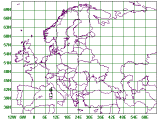
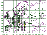
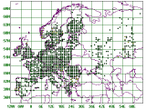
In national or regional maps small 'squares' are necessary to express the distribution of a species and its changes; thus one dot could indicate, for instance, a 'square' of the size of approximately 10 × 10 km. Such dots scaled down to fit a European map of the size of some 17 × 13 cm would become almost invisible and the quantity of records would reach intolerable proportions. For the purpose of this project 'squares' based upon the latitude and longitude expressed in grades and minutes are utilised, one MEB basic recording field (BRF) - i.e. grid unit or 'square' - measuring 30' × 60'. It appears that an area of 30' × 60' makes the ideal grid on a European scale.
The standard grid units in map-making are latitude and longitude, expressed in geographical coordinates measured in grades, minutes and seconds, and utilised in all maps regardless of scale and projection. The only drawback of this system is that the 'squares' (i.e. BRF) determined by the same number of grades, minutes or seconds are not of the same size. Whereas the latitude remains constant (30' measures about 55 km) on the European scale, the longitude of 60' varies according to the latitude. It measures in southern Europe at 40°N (e.g. Sicily) about 85 km, in central Europe at 50°N (e.g. Germany) about 72 km and in northern Europe at 60°N (e.g. Sweden) only about 52 km. There is no rational way of compensating for this drawback. It is occasionally argued that placing the dot indicating a locality exactly on the spot of the site can help; this is not true as the dots are generally too large to indicate a single site and they tend to overlap and obscure the map. The only way of avoiding the overlap is by use of a suitable grid. The projection of the map utilised for MEB is equidistant cylindrical with the standard parallel at 51°N.
The next point to be considered was the form of data input. In view of the vast amounts of data to be expected an effective, simple method of data input had to be invented. Of course, it would have been possible to work directly with co-ordinates but their use would have made the data subject to many errors and their input very awkward, and certainly subject to further errors. Furthermore, it is much easier to check any record under the name of a reference locality than under impersonal geographical co-ordinates. In Czechia, where detailed topographical maps were forbidden for general use from 1949 until 1989, a useful system of preselected localities referring to map 'squares' was devised by NOVAK (1989) and (after some minor corrections and additions) utilised by KUDRNA (1994). Although good quality detailed topographical maps are now easily obtainable, the above system is still being widely used in Czechia. A similar system is also being used in Norway and possibly in other European countries. A simple system based on these lines was needed for MEB. After thorough consideration the Reference Locality System (RLS) was conceived. |
|||||||||||||||


 Email to Webmaster